RER Train Line Maps
The following RER Train Line maps are specific to a single RER Train line, A, B, C, D, or E.
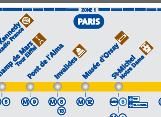
Each RER Line map shows:
- Stations along the RER line
- Branches & Terminus (last) stations for each branch, used to specify direction of travel for RER trains along their platforms within stations
- Interchanges or Connections to Paris Metro lines
- Connections to other RER train lines
- Transfers to TGV Trains, Transilien/Ter commuter train lines at large Paris train stations (known as “Gare” in French). This includes Gare du Nord, Gare de l’Est, Gare de Lyon, Gare de Austerlitz, Gare de Montparnasse, Gare St. Lazare.
- Zones for Pass Navigo / Paris Visite / Mobilis tickets and passes
- Handicap accessibility at stations
- Famous attractions near stations
These maps can be found on all RER train cars just above their doors.
What Next?
- Search:
- Ask a question

I want to support Ben
RER Train Line Maps was last modified: October 28th, 2019 by
Pingback: How to Read an RER Train Schedule / Timetable | Paris by Train