For those who prefer large print, print this PDF metro map using regular or high quality 8.5 x 11″ paper in landscape mode and then fold it like a letter or a brochure so that the middle of the sheet doesn’t become creased and illegible after folding and re-folding.
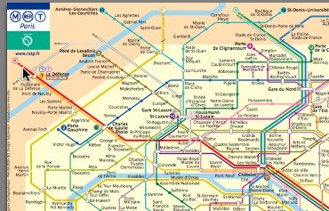
This RATP Paris Metro RER map covers all 14 metro lines (16 if you include the “bis” lines) and the 5 regional train lines RER A to E. The Metro RER Zones are not printed on this map but the darker shade is Zone 2, with the lighter tan/beige being Zone 1 or Central Paris. There are a lot of popular destinations outside of Paris that are noted near the edges of this map, but the stops aren’t actually shown, such as Charles de Gaulle (CDG) and Orly (ORY) airports. For those destinations you’ll have to download the Paris RER Map.
Paris METRO RER MAP (PDF) (courtesy of RATP)
What Next?
- Search:
- Ask a question

Hi my name is Ben and I’m the creator & author of Parisbytrain.com. I want to empower you with the knowledge & confidence to travel Paris like a local through personally researched, in-depth articles like CDG to Paris by train and the Paris Metro. I moved to Paris in 2006 and started Parisbytrain.com in 2008 to share what I’ve learned about the vast & comprehensive Paris train network. Have Paris train questions? Ask them here. Have a great visit to Paris!
I want to support Ben
Pingback: Closest Metro Stations to the Eiffel Tower | Paris by Train
Pingback: Ten Tips for the Paris Metro | Paris by Train
Pingback: Gare Montparnasse Photo Tour | Paris by Train
Pingback: Paris Metro Map « Paris by Train
Pingback: Paris Metro Maps | Paris by Train