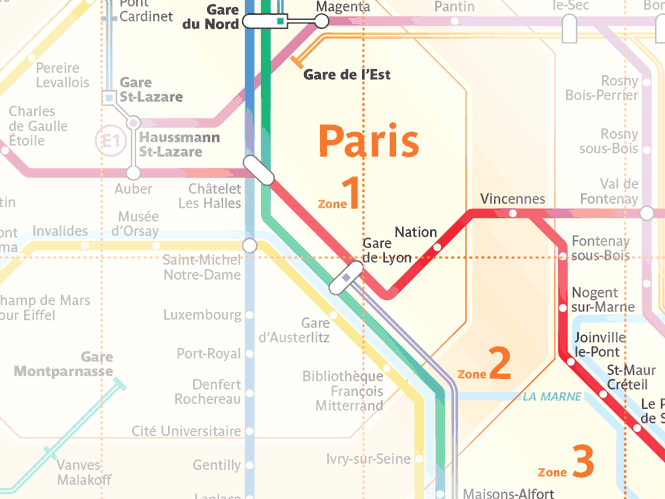
Paris and the surrounding area is divided into 5 circular transportation fare zones for use in pricing Paris public transportation passes & multi-use tickets. This applies to passes used on Paris RER trains, buses, trams and Transilien commuter trains. Note: These fare zones do not apply to the Paris Metro (subway) system! For the Paris Metro, all Metro lines and all Metro stations are not affected by fare zones. We can effectively consider Paris Metro subway trains as operating in a single zone even if the Metro line crosses into zone 2 or zone 3.
New for 2025 – Most Paris Transport Tickets & Passes Cover All 5 Zones
As of January 1, 2025, nearly all Paris transport fares/tickets are good for all zones 1-5 (though only a few include CDG/ORY airports by default). CDG & ORY Airports are considered a special fare zone even though they are within Paris fare zone 5.
Information on the new 2025 fares (Paris Metro-Train-RER ticket, Paris Bus-Tram ticket) and changes to the existing fares will be coming shortly. Links to the new articles will be added to table below when complete.
| All 5 Fare Zones – No Airports | All 5 Fare Zones + CDG/ORY Airports | Limited Coverage |
|---|---|---|
| Navigo Day Pass | Navigo Week Pass | Ticket t+¹ |
| Paris Metro-Train-RER ticket | Paris Visite | RER Ticket (pre-2025) |
| Paris Bus-Tram | Paris Region Airports | Bus Ticket |
| RER Ticket (in 2025, no airports) | Ticket Anti-pollution | |
| Fete de la Musique |
¹ Ticket t+ is a paper Paris Metro/Bus/Tram ticket being phased out in 2025 & replaced by the Paris Metro-Train-RER digital ticket fare.
Paris fare zones still apply to some Paris transport tickets and passes in 2025 although most fares now cover all 5 zones. The old-style Paris Metro/RER/Bus/Tram paper tickets known as Ticket t+ are only valid for fare zone 1 for RER trains, but the entirety of the Metro system, regardless of zone. The Navigo Week Pass pass covers all 1-5 zones by default, including CDG/ORY airports, as does the new 2025 version of the Paris Visite fare (digital only for 2025 on Navigo Easy & smartphone apps). Navigo Jour Day pass in 2025 now covers all Paris zones 1-5 by default; the choice for smallers zones 1-2, 1-3, 1-4 has been removed.
Examples of popular destinations and their zones:
- Chateau Versailles & Orly Airport – Zone 4
- CDG Airport & Disneyland® Paris – Zone 5
- Fontainebleau – Zone 5
This Paris Train Zone Map (880KB PDF) displays train zones for RER trains, Transilien trains, Trams throughout fare zones 1 to 5 which applies to:
- Pass Navigo / Pass Navigo Decouverte
- Ticket t+
- RER tickets pre-2025
- Bus tickets pre-2025
Ticket Mobilis (day pass)discontinued Jan. 4, 2024Ticket Jeunes (day pass for 25 and under, valid only on weekends/holidays)discontinued Jan. 1, 2025
Paris Metro Zone
Paris Metro (urban city subway) is all a single zone even though it has stations in Zones 1, 2 & 3 as shown on this more detailed zone map including Paris Metro, RER and Transilien (intercity) trains (900KB PDF, opens a new window). The old style Paris Metro Ticket t+ paper tickets and the new Paris Metro-Train-RER tickets are valid for travel anywhere* on the Paris Metro system, end-to-end, since it is a single continuous, zoneless system requiring only a single Metro Ticket t+ (even if the Metro station is outside of Zone 1) or the new 2025 Paris Metro-Train-RER fare. *Orly Airport on Metro 14 is not included!; Orly by Metro 14 has a “special airport fare”. See Orly Airport Train – Metro 14 article for more information.
Paris RER Zones
The Paris regional RER train system is different & previously used zones/distance traveled to set fare prices. New in 2025: RER tickets (the old-style paper Billet Origine-Destination tickets) now all cost the same (2.50€) regardless of stations traveled within the 5 zones. RER, Transilien, TER trains traveling outside of zone 5 are priced higher and still depend on the stations traveled.
New in 2025, travel between any RER stations in Paris zones 1 to 5 are now the same price: the price of a single Paris Metro-Train-RER ticket: 2.55€ (1.30€ for kids 4-9).
The old-style Ticket t+ Paris Metro tickets can still ride Paris RER trains, but only within zone 1. The new Paris Metro-Train-RER fare on Navigo Easy / smartphone apps /Apple Wallet is good for all 5 zones using any Paris Metro, Paris RER, Transilien train. (Buses & Trams are not included on the Paris Metro-Train-RER ticket & require the new Paris Bus-Tram ticket.)
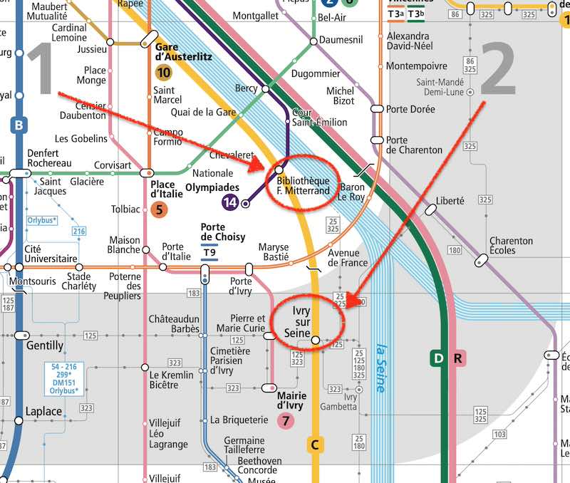
In 2024 and earlier, once a Paris RER train crossed the border between zone 1 and zone 2, a RER ticket (billet origine-destination) was required. For example on the south eastern edge of zone 1 are two RER C stations right next to each other: Bibliothèque François Mitterrand (in zone 1) and Ivry sur Seine (in zone 2). This trip takes 3 minutes, but used to cost 2.30€ with the proper RER ticket while the old Paris Metro ticket t+ (not valid for this trip) used to cost 2.15€. This is being eliminated / simplified with the new Paris Metro-Train-RER ticket which covers both Paris Metro and Paris RER, out to all 5 zones. And prices have been normalized across the old Paris Metro ticket t+, old Paris RER tickets and the new Paris Metro-Train-RER ticket, which in 2025 all cost 2.50€. So there is little reason to buy either the old Paris Metro ticket t+ or Paris RER ticket now in 2025.
Paris Zone 1 to Zone 2 needs RER ticket
If riding Paris Metro line 1 using the Ticket t+ paper ticket, be careful at La Défense when exiting the Metro area. Be sure to use the Metro exit and not the RER exit, both of which may be available to you due to fences which may be opened at particular times (rush hour). A RER ticket is required to pass through RER exit turnstiles, while the Metro exit will not require a ticket and will open with weight or infrared operated gates & turnstiles.
What’s visible on the Zones map:
- Fare Zones (“Zones Tarifaires”) 1 through 5
- RER A, RER B, RER C, D, E train lines
- RER & Transilien train network in Ile-de-France (administrative region around Paris)
- Station names along all RER/Translien train lines
- Connections (“Correspondances”) and transfer possible between different RER, Transilien, and RER to Transilien trains
- Shuttle bus (“navettes bus”) from RER C station: Pont de Rungis and Orly Airport
- Orlyval train to Paris-Orly Airport between RER B station: Antony and Orly West / Orly South airport terminals, which requires a special fare (“tarification spéciale”)
- Major tourist sites (“Sites touristiques”) accessible from certain stations
(Zone map courtesy of RATP)
What Next?
- Search:
- Ask a question

I want to support Ben
Pingback: Airport to Paris - Terminal 1 | Paris by Train
Pingback: Carte Orange | Paris by Train
Pingback: Gare de Lyon Photo Tour | Paris by Train
Pingback: Paris Train Ticket Machine | Paris by Train
Pingback: RER Train Paris to Euro Disney | Paris by Train
Pingback: EuroDisney Comment Arrivée | Paris by Train
Pingback: Orly (ORY) to Central Paris Transportation | Paris by Train
Pingback: Charles de Gaulle Airport (CDG) to Paris by Train | Paris by Train