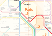
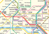
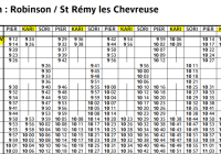
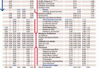
Maps

Here you will find a collection of downloadable Paris Metro, RER & train maps followed by excerpts of Map related articles.

Jump to an article:


Paris Train Maps Collection

In downloadable/printable PDF format. (Maps are provided courtesy of RATP and Transilien).

RER Train Map - Regional Express Train network (RER) connecting popular destinations to central Paris such as Charles de Gaulle Airport (CDG), Orly Airport, Eiffel Tower. Includes train lines RER A, B, C, D, E in central Paris extending out into the Ile-de-France region.

Paris Metro Map - Paris Subway network (Metro) with Metro Lines 1 through 14 serving central Paris. Map includes RER A-E trains, plus Tram lines 1, 2, 3.

Compact Paris Metro Map - Compact version of Paris Metro map, suitable for high quality 4×6 printing on photo paper. Instructions on printing the Compact Paris Metro Map.

Metro Map with Streets - Metro Lines shown in relation to city streets within Paris.

Paris Public Transport Zone Map - Map showing the 6 fare zones for Paris and surrounding region. Applies to Paris travel passes: Pass Navigo / Carte Orange, Pass Navigo Decouverte, Paris Visite, Ticket Mobilis/Jeunes valid on Paris Metro, RER, Tram, Buses, and trains. For more information see Paris Fare Zones.

Paris Airports Paris Airport Transportation Map - Simplified version of Paris RER/Bus map showing routes connecting Paris to CDG (Roissy-Charles de Gaulle) and ORY (Paris-Orly) Airports.

TGV Train Map - High Speed Train (TGV) network map covering France. (courtesy of RailEurope.com)

Paris Airports CDG Airport Map - Overview map of Aeroport Charles de Gaulle’s three terminals: Terminal 1, Terminal 2 and Terminal 3.

Paris Airports Orly Airport Map - Overview map of Aeroport Paris-Orly’s (ORY) two terminals: Orly West (”Orly Ouest”), Orly South (”Orly Sud”).

RER Line Maps (below) - Detailed information on individual RER train lines A through E with station names, fare zones, terminus (end-of-line) stations on line branches. Shows stations with:

  • connections to Metro lines & other RER lines,
  • access to highspeed (TGV) and commuter (Transilien) trains at large train stations (”Gare”),
  • access to tourist attractions (Eiffel Tower, Notre Dame, Orsay Museum, etc.)
  • handicap accessibility

Euro Disney RER A Line Map - For more information see RER A train schedule and line map.

Paris Airports RER B Line Map - For more information see RER B train schedule and line map.

RER C Line Map - For more information see RER C train schedule and line map.

RER D Line Map

RER E Line Map

Wheelchair Accessibility Map - Shows RER & Metro stations accessible by people with movement impairment or requiring a wheelchair. Also shows Bus lines inaccessible by wheelchair.

Excerpts of Maps Articles

Click on a title to view the full article.

  • TGV Map

    France TGV Map showing high speed train lines in deep purple and light purple (click to enlarge).

    This TGV Map shows the main TGV destinations in France:

    Paris
    Rennes
    Nantes
    Bordeaux
    Montpellier
    Marseille
    Lyon
    Strasbourg

    The…

  • Virtual Tour of Paris Streets on Google Maps

    You can now take a virtual walking tour of Paris with Google’s Street View service on Google Maps.

    As you can see, the…

  • Paris Metro Maps

    Official Paris Metro (subway) maps for download below. (Click on the map to download the PDF).
    Basic Metro Map
    Shows all 14 main Metro lines and 2 secondary “bis” lines, RER lines A through E and Tram…

  • Map Paris Wheelchair Reduced Mobility Accessibility - Metro RER Bus Tram

    Here is an accessibility map of Paris Metro, RER, Bus, Tram lines, stops and stations for those with reduced mobility, specifically for those in a wheelchair.

  • Paris Metro & Train Route Planner

    These online Metro, RER, Trains, bus route & schedule tools will show you how to get from point A to point B. These route planners show required connections between train lines, travel times and ticket…

  • High Speed Rail Map - Europe

    This rail map from TGV-Europe.com shows high speed train lines in France & Western Europe along with:

    train ticket prices between cities
    travel times
    number of trains per day for each journey

  • France TGV Map

    This TGV Map shows high speed train lines in France. This includes the main TGV lines, Eurostar, Thalys, TGV East networks. (Click map to see full version).

  • RER Train Line Maps

    RER Train Line Maps
    The following RER Train Line maps are specific to a single RER Train line, A, B, C, D, or…

  • Paris Transportation Zone Map

    Paris and the surrounding area is divided into 6 concentric zones for use in pricing public transportation passes.  Travel into the 6th…

  • RER C Train Map

    This RER C Train Map shows:

    All stations along each RER C branch (C1 - C7)
    Interchanges with Metro Lines / RER Lines
    Famous Sites and Attractions at stations on RER C
    Zone regions (Zone 1 to Zone…

  • Paris Street Map

    The best detailed Paris street map to buy is The Paris Mapguide from Michael Middleditch.  I’ve not found a Paris street too small to be included in this book.  There are some outlying…

  • RER A Line Map Panel

    This is a photo of a RER A Line Map within Gare de Lyon showing it…

  • Closest Metro Stations to Arc de Triomphe

    (Photo by *Solar Ikon*)

    Closest Paris Metro stations to the Arc de Triomphe:

    Charles de Gaulle Etoile - Line 1 (yellow)
    Charles de…

  • Closest Metro Stations to Notre Dame

    The closest Paris Metro stations to the Notre Dame Cathedral are:

    St-Michel Notre Dame - RER B Train Line (blue)
    St-Michel Notre Dame…

  • Closest Metro Stations to Sacre Coeur

    The closest Paris Metro stations to the basilica Sacre Coeur include:

    Abbesses - Line 12 (green)
    Anvers - Line 2 (blue)
    Lamarck Caulaincourt - Line…

  • Closest Metro Stations to Paris Opera

    The Opera House in Paris (Opéra Garnier) has several nearby metro stations including:

    Opera (Line 3, Line 7, Line 8)
    Chausée d’Antin La Fayette (Line…

  • Closest Metro Stations to Louvre Museum

    The closest Paris Metro station to the Louvre Museum is Louvre Rivoli and Palais Royal Musée du Louvre, both on Line 1 (yellow) which…

  • Closest Metro Stations to the Eiffel Tower

    The closest Paris Metro station to the Eiffel Tower is Champ de Mars / Tour Eiffel on line RER C. Other Metro…

  • Paris RER B Schedule Stations Interchanges

    Below you will find downloadable / printable schedules for Paris RER B trains which travel between CDG Airport and central Paris stations.
    RER B Schedule / Timetable
    From Charles de Gaulle (CDG) Airport to Paris

    First train…

  • Paris RER A Train Schedule Stations Interchanges

    Overview

    Going from Paris to Euro Disney? This is your schedule and Marne la Vallée is the Paris Disneyland station. See also help on reading RER schedules.…

  • Paris RER Map

    Here is a detailed map of RER A to RER E lines in and around Paris and its surrounding suburbs. Unlike the Paris metro system which…

  • Paris Metro RER Map

    Here you can find and download a detailed Paris Metro/RER Map perfect for printing on an inkjet printer. 4×6 photo paper works best, which…