Paris RER A Timetable Open Hours First Last Trains
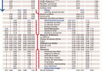
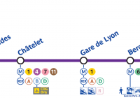
RER A Timetable / Schedule (Paris – Disneyland Train) In this article you’ll find an example RER timetable for First / Last RER Train Disneyland Paris plus a full RER A timetable for Paris to Disneyland trains and full RER A schedule for Disneyland to Paris trains. First / Last RER Train Disneyland Paris The … Read more